|
| Products |
| |
 |
| |
| Introduction |
| |
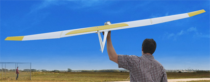
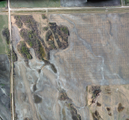
| The CropCam is a revolutionary mini agriculture plane that changes the way you manage your crops, fields or any part of your agricultural operation, by providing high resolution GPS based digital images for precision agriculture Hand launched, the CropCam includes a miniature autopilot, camera, GPS and software to provide images on demand. |
 |
|
 |
| How it Works |
| |
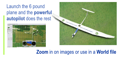
| The CropCam is a radio controlled model glider plane equipped with a Trimble GPS, a miniature autopilot and Pentax digital camera. Hand launched and automatic from take off to landing, the CropCam provides high resolution GPS based images on demand. Simply stand at one corner of your field and hand launch the 6 pound CropCam plane. The powerful miniature autopilot and Trimble GPS, does the rest navigating in a pattern over the field. Both the CropCam and the camera perform automatically to take GPS based digital imagery. After the flight the CropCam will land in the spot you started from. |
| |
| For further analysis, you can choose and zoom in on each image separately. Each individual image is GPS based with latitude, longitude and altitude. Finally, the CropCam Image Software allows you to export images in TIFF format with associated World files (.tfw) for use with other Geo reference software. |
| |
| Benefits |
| |
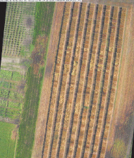
| Precision agriculture has become a buzz word for the agriculture industry and has received growing attention. In addition to GPS mapping, auto steer and variable rate spray, GPS aerial images are being used for crop analysis such as plague scouting, disease scouting and plant development. |
| |
| Traditional aerial images provided by satellite, manned aircraft or stock photography are often expensive, difficult to obtain or outdated. The CropCam provides GPS based digital images on demand throughout the growing season. The images obtained through the CropCam will allow producers to detect, locate and better assess the actions required to correct the problem. |
| Specifications - Electric |
| |
| Length |
4 feet |
| Win span |
8 feet |
| Weight |
6 pounds |
| Engine |
Brushless Electric |
| Batteries |
Lithium Polymer |
| Altitude |
400 - 2200 feet in Canada
(Can be adjusted to meet regulation or application) |
| Flight duration |
55 minutes |
| What is the spatial resolution of the imagery acquired from CropCam? |
| |
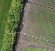
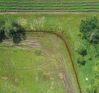
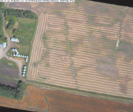
| Images acquired at 2100 feet above ground have a spatial resolution of approximately 15 cm. However, increased spatial resolution can be achieved by simply programming the CropCam to fly closer to the ground. |
| |
 |
| How does CropCam imagery compare to satellite imagery? |
| |
| There are a number of advantages that CropCam has over traditional based image acquisition systems, including: |
| |
- Acquire imagery below the cloud canopy allowing for imagery acquisition even on cloudy days. Satellite based systems may go months before your area of interest has imagery acquired for it.
- Increased temporal resolution means CropCam can be deployed to acquire imagery where you need, when you need. Satellite based systems may only acquire imagery for your area of interest every 16 days.
- Spatial resolution of 15 cm is 40,000 times better than that of some of the most widely used satellite systems and has 44 times more resolution than the most advanced satellite based systems currently in operation.
- Satellite based systems have a lag between when the imagery is acquired and when you can purchase it. With CropCam you will have the imagery within minutes of it landing and within a few hours if more complex image processing is required.
|
| Agriculture |
| |
| CropCam gives timely imagery that allows producers and those who advise them to make more informed decisions which can save money. The images can be acquired and viewed almost instantaneously. |
| |
- Quickly and accurately decide whether or not to spray and where.
- Get peace of mind with a permanent record of the extent of crop damage.
- Assist in the identification of crop scout locations and create waypoints that can be loaded on to your GPS unit.
|
| Environmental Monitoring |
| |
| CropCam provides flexibility and economic deployment that allows for a regular schedule of imagery to be acquired. This opens the door to many land and water environmental monitoring applications which were previously not economically viable. |
| |
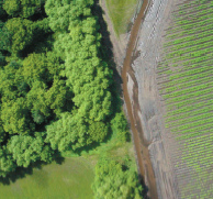
| Forestry |
| |
| High resolution imagery gathered from the CropCam will allow forest companies and private land owners to assess their woodlots. This includes specie identification and extent as well as volume calculations. More informed and accurate forest cutblock boundary with help ensure these resources stay healthy for future generations. |
| |
| Resources |
| |
| For an overview on CropCam see Overview of CropCam [WMV] |
| |
| |
| Required equipment such as Radio Control (RC) items, laptop and camera are not included. These additional items must be purchased separately. See Additional equipment list. |
|
|